Admission of Candidates to Research or Higher Degree Programmes for 2019/2020 Academic Year

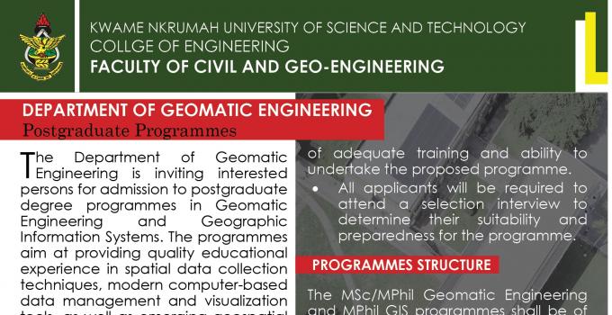
The Department of Geomatic Engineering is inviting interested persons for admission to postgraduate degree programmes in Geomatic Engineering and Geographic Information Systems. The programmes aim at providing quality educational experience in spatial data collection techniques, modern computer-based data management and visualization tools, as well as emerging geospatial technologies throughout Ghana and beyond.
Entry Requirements
The MSc/MPhil/Phd Geomatic Engineering is open to professionals in the following fields:
Engineering, Surveying, Architecture, Building Technology, Planning, Land Economy, Real Estate, Agriculture, Landscape Design & Management, Natural Resource Management, Forest Resource Technology, Computer Science, Environmental Science, Meteorology and Climate Science, Geography and Rural Development.
a. MSc/MPhil Geomatic Engineering
Applicants must have a minimum of Second Class (Lower) Division degree or its equivalent from a recognized University in the relevant field of study.
b. MPhil/MSc Geographic Information System (GIS)
Applicants must have a minimum of Second Class (Lower) Division degree or its equivalent from a recognized University in the relevant field of study.
c. PhD Geomatic Engineering
Applicants must have an MPhil degree or its equivalent from a recognized Institution and shall submit evidence of adequate training and ability to undertake the proposed programme.
- All applicants will be required to attend a selection interview to determine their suitability and preparedness for the programme.
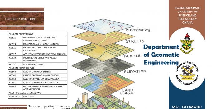
Programmes Structure
The MSc/MPhil Geomatic Engineering and MPhil/ MSc. GIS programmes shall be of two (2) years duration. The first year will be two (2) semesters of taught courses and the second year will be for supervised research and thesis report preparation. Options under the MSc/MPhil Geomatic Engineering programme are:
- Land Administration
- Geodesy
- Remote Sensing and Photogrammetry
- Geographic Information Systems
For the Mphil/MSc GIS programme, classes will be held mainly on weekends.
The PhD Geomatic Engineering programme shall be of three (3) years duration. The first year will be for two semester taught courses, supervised research and seminars. The second and third years will be for research, seminars and thesis report preparation.
Mode of Application
Suitably qualified persons can apply through the KNUST admissions portal
Download brochure for more information.
Recent News

15th Surveyors' week and 51st AGM
11 Feb 2020